The Kemerovo Region is located in the southeast of Western Siberia. On the satellite map of the Kemerovo region, you can see that the region borders on the Republics of Khakassia and Altai, Altai and Krasnoyarsk territories, Tomsk and Novosibirsk regions. The area of the region is 95,725 sq. km.
The territory of the region is divided into 18 municipal districts and 20 cities. The largest cities of the Kemerovo region are Kemerovo (administrative center), Novokuznetsk, Prokopievsk, Mezhdurechensk and Leninsk-Kuznetsky.
On the territory of the Kemerovo region there is one of the centers of the Russian coal industry - Kuzbass. The region's economy is based on coal mining, oil refining and metallurgy.
Kuznetsk Alatau
Brief history of the Kemerovo region
The development of the territory of the modern Kemerovo region began in the 17th century. In the XIX century, the region was part of the Tomsk province. In 1930, the region became part of the West Siberian Territory, and in 1937 - Novosibirsk region. In 1943, the Kemerovo region was organized.
On September 18, 1984, a peaceful nuclear explosion was carried out 100 kilometers from Kemerovo, the power of which was 10 kilotons.

Kuznetsk fortress in Novokuznetsk
Sights of the Kemerovo region
On the detailed map The Kemerovo region from the satellite you can see some natural attractions: Shorsky National Park, the Kuznetsk Alatau Reserve, the mountainous region of Mountain Shoria and the Kuznetsk Basin.
In the region, it is worth seeing the highest point of the region - Mount Upper Tooth (2178 m), Mount Kul-Taiga, on top of which there is a mountain lake, the valley of the Mras-Su River with numerous caves, the Saga waterfall, Lake Berchikul, Gavrilov caves, rocks "Spassky Palaces" and "Royal Gates".

Ski center Sheregesh
There are several well-known ski resorts in the Kemerovo region: Yugus near Mezhdurechensk and the village of Sheregesh on Zelenaya Gora. It is also worth seeing the Kuznetsk Fortress, the Transfiguration Cathedral and the Catholic Church of John Chrysostom in Novokuznetsk, the Znamensky Cathedral and the Red Mountain in Kemerovo.
Note to the tourist
Gulrypsh - holiday destination for celebrities
There is an urban-type settlement Gulrypsh on the Black Sea coast of Abkhazia, the appearance of which is closely connected with the name of the Russian philanthropist Nikolai Nikolaevich Smetsky. In 1989, due to the illness of his wife, they needed to change the climate. Case decided the case.The administrative center of the Kemerovo region is the city.
And now you can see what it looks like. 
- !!! Dear readers, there is a main article on my blog, where you will find not only maps of all subjects Russian Federation, but also maps of rivers, lakes, cities and much more.
Demonstrates the features of the south of Western Siberia. The region itself was formed in 1943 by a corresponding decree of the Supreme Soviet of the USSR. The head city of the region is Kemerovo, and the largest is Novokuznetsk. The region is limited by the Novosibirsk and Tomsk regions, the Altai and Krasnoyarsk Territories, and the republics of Altai and Khakassia. The area is huge, and the population is only 3 million, so the average density of development of this territory is lower than the national average.
The relief of the region is very diverse. A significant part of it is occupied by the Kuznetsk Basin. In the southeast, landscapes adorn the spurs of the Altai and the Sayan Mountains. In the west is located low, but extremely curious. from the point of view of the manifestation of weathering forms, the Salair Ridge. The legendary landscapes of mountain Shoria, with relict trees, adorn the south. All this shows map of the Kemerovo region.
The tectonic structure and the history of the development of the territory gave the region a lot of minerals, safely hidden in the bowels of the earth. Huge reserves of hard and brown coal were formed in the Paleozoic. Deposits of iron, polymetallic, and gold ores are associated with the emergence of the West Siberian Platform. In addition to these treasures, there are also phosphorites, in unlimited quantities, and a hundred kinds of various semi-precious and decorative stones.
Such a rich base has allowed, for a long time, to develop the mining, metallurgical, energy and machine-building industries in the Kemerovo region.
The history of the Kemerovo region began by historical standards not so long ago - in the 18th century. It all started with the fact that one day Mikhailo Volkov went up the river and saw a huge coal seam. This place is now Kuzbass. Industrial development of this land began only at the end of the century. There are factories of industrialists, whose names are already known throughout Russia. Since then, life has been developing here very actively, because the mined coal must be sold, and in order to sell it, you need an entrance to the mines and factories. In general, this area has been developing quite actively all the time since the discovery of coal, stagnation was forced only during the years of the Second World War.
Coal is, of course, the region's main attraction. What else can you see besides it? For example, rare rock carvings in the museum-reserve "Tomsk Pisanitsa", the eco-museum "Tazgol", in the black taiga you can see rare relic plants, in dense forests there are wild animals wolverine, sable, wolf.
The Kemerovo region is one of the breadwinners of Russia, with its unique history and architecture, which is constantly changing.
Often, traveling through the expanses of the Internet, I come across various interesting facts in articles. I especially love sites about interesting facts, I can hang on them for the whole day, it's so exciting and informative.
If you think that my articles about this Russia are useful, then here are a few more articles about it on my site, as well as:
You may also be interested in the cities of the Kemerovo region:
| City | Year of foundation | The area of the land,sq. km. |
| Anzhero-Sudzhensk | 1931 | 120 |
| Belovo | 1938 | 170 |
| Berezovsky | 1965 | 82 |
| Guryevsk | 1938 | 90 |
| Kaltan | 1959 | 32 |
| 1918 | 279 | |
| Kiselevsk | 1936 | 215 |
| 1925 | 128 | |
| Mariinsk | 1856 | 48 |
On the satellite map of the Kemerovo region you can see big number rivers and lakes. The most significant reservoirs are:
- Berchikul;
- Tom;
- Condoma;
- Sary-Chumysh;
- Chumysh;
- Mrass.
The subject is rich in mineral resources. On the territory of the Kemerovo region, gold, iron and polymetallic ore, brown coal, phosphorites and other minerals are mined. There are fertile black soils used in agriculture in the region. The climate in the region is continental. Summers are short but warm, while winters are long and cold.
- The coldest month is January. The temperature drops to minus 20 degrees;
- The warmest is July. The air warms up to +20 degrees.
The flora of the subject is diverse. Tundra plants, alpine meadows grow in the mountains, fir-aspen and pine forests grow in the foothills. There are steppes and forest-steppes. There are many nature reserves in the region. The fauna of the region is no less interesting. There are more than 20 species of animals, 120 species of birds.
Road communication of the Kemerovo region, routes
- Federal P255 "Siberia". Novosibirsk - Irkutsk;
- P384. Novosibirsk - Yurga;
- Novokuznetsk Ring Road (NKAD);
- P366. Altai Territory - Novokuznetsk;
- P400. Tomsk - Mariinsk;
- Kemerovo Ring Road (KKAD).
There are also other highways in the region. On the online map of the Kemerovo region with borders, it is noted that the Trans-Siberian Railway passes through its territory. There is a branch of the West Siberian railway. There are more than ten stations in the region. There are airports in Kemerovo and Novokuznetsk, there are 4 more airfields in other settlements. During navigation on the Tom River, water transport runs.
Kemerovo region with settlements and districts
On the map of the Kemerovo region with districts, it is indicated that there are 19 cities of regional subordination in this region. The capital of the subject is Kemerovo. Over 550 thousand people inhabit this city. In total, there are 19 districts in the region:
- Belovsky;
- Krapivinsky;
- Leninsk-Kuznetsky;
- Kemerovo;
- Izhmorsky;
- Guryevsky;
- Mariinsky;
- Topkinsky;
- Chebulinsky;
- Yurginsky;
- And others.
2 million 709 thousand people live in the region. They are mostly Russians, as well as Shors, Tatars, Teleuts and citizens of other nationalities. There are 20 urban and over 150 rural settlements on the territory of the subject.
Given array? You will find answers to these and other exciting questions in our article. We will also consider the sights of the city of Kuzbass. Where is he? More on this later in the article.
Kuzbass is located between the medium-high highlands of the Kuznetsk mountain range and the Salair mountain range, located in the southern part of Western Siberia. Its official name is the Kuznetsk coal basin. The area is more than 95 thousand km².
Talking about where Kuzbass is located, I would like to say that its second name is the Kemerovo region, given that the main part of the coal basin belongs to it. The regional center of the region is the city of Kemerovo.
History of the Kemerovo region (Kuzbass)
Talking about where the Kuzbass basin is located, you need to remember its history. Representatives of the Turkic-speaking people (Shors), Siberian Tatars and Teleuts settled on the territory of the modern Kemerovo region several thousand years ago.
At that time, it became necessary to protect this region from external enemies, and at the beginning of the 17th century (in 1618) the Kuznetsk fortress was built. Around it, on the banks of the Tom River (a tributary of the Ob), the future city of Novokuznetsk grew.
Eighty years later, at a distance of 380 km from Kuznetsk, the city of Mariinsk appeared on the Kiya River. According to historical documents, these two cities are considered the oldest cities in the Kuzbass coal basin.
More than 300 years ago, the Emperor Russian Empire Peter I was informed that an expert in mining - a serf peasant Mikhail Volkov - discovered a coal deposit.
In 1821, Pyotr Chikhachev, an honorary member of the St. Petersburg Academy of Sciences, identified large deposits of coal in the Kemerovo region, which the scientist called the "Kuznetsk coal basin".
At the end of the 18th century, coal mining began. After some time, industrial metallurgical and silver-smelting enterprises were created.

The Ural industrialist Nikita Demidov, who created a whole network of metallurgical plants, became interested in the development of Kuznetsk coal. A big impetus in the development of the Kuznetsk basin was the construction in 1898 of the Trans-Siberian Railway (Trans-Siberian - the Great Siberian Way).
Where is the Kuzbass coal basin located? Its development
The revolutionary events in Russia suspended the activities of Kuzbass factories. But since 1920, restoration work began at all factories, which became state-owned enterprises.
During this period, schools, institutes, theaters were built in the cities, museums and many other cultural institutions were opened. In the period from 1931 to 1939, where Kuzbass is located, eight modern educational institutions for that time in the city were built.
Until 1942, the regional center was the city of Novokuznetsk. By decision of the government of the USSR, since 1943, on the territory where the city of Kuzbass is located, which used to be part of the Novosibirsk region, the Kemerovo region was created with the regional center Kemerovo.
Now there are 20 cities in the region. Where Kuzbass is located, there are 58 mines, coal and metallurgical plants and 36 open-pit coal mining enterprises (quarry method).
In addition, Kuzbass, where all conditions have been created to be the first in the Russian ranking in coal mining and fourth in steel production, has four universities, nine institutes and twenty colleges in various specialties.
In our time, Kemerovo and Novokuznetsk are considered major cities in terms of population and area. They are home to over a million indigenous people.
Kemerovo
On the banks of the rivers Bolshaya Kamyshnaya and Tom there is a regional center - Kemerovo - with an area of 280 km².
There was a Russian settlement on the territory of the future administrative center of Kuzbass.
Historical documents testify that it was formed from the junction of two small villages - Shcheglovo and Kemerovo. This happened in 1734.
The mining village has become popular among lovers of skiing and those who want to relax in the silence of untouched taiga nature.
Ecomuseum "Tazgol"

There is another attraction in the Tashtagol region - the open-air ecological museum "Tazgol". It is located in the village of Ust-Anzas.
The museum, created in 1992 by archaeologists together with ethnographers from Kemerovo University, is located on an area of 5 hectares. Here are collected monuments of culture and life of the population of the region of past centuries.

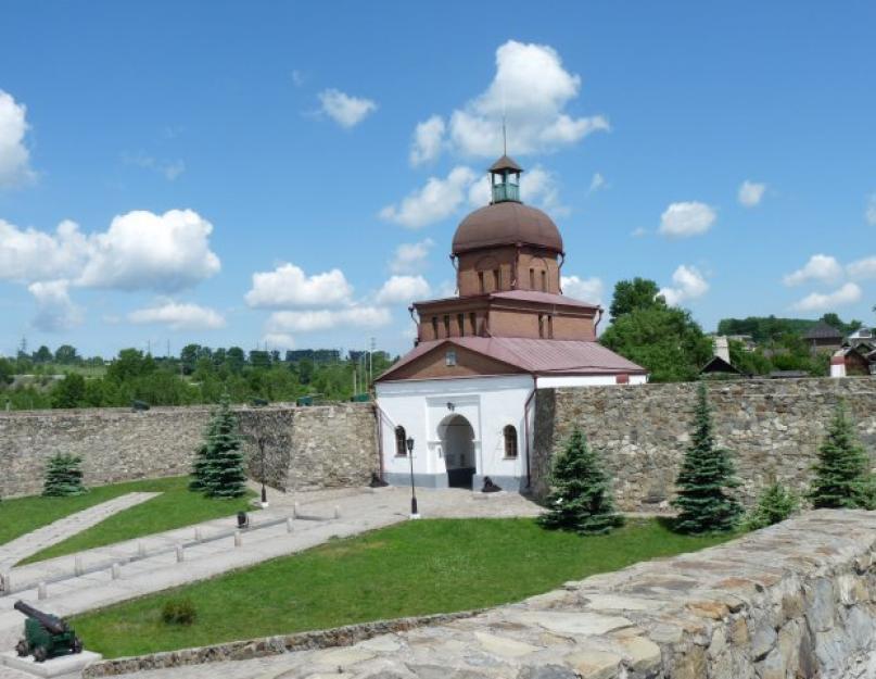
Kuznetsk fortress
On the territory of Novokuznetsk is the main attraction of the city - the Kuznetsk fortress. The fort was built in 1800 at the direction of Russian emperor Paul I. The bastion is a complex of buildings located on the territory of 22 hectares.
The peculiarity of this structure lies in the fact that throughout its history the fortress did not take part in military events. After 70 years, the citadel was converted into a Kuznetsk prison.
Since 1917, the buildings of the fortress have been used for various city institutions. And after the last restoration, carried out on the eve of the 390th anniversary of the city, the fort is open to history buffs.
Lakes of Kuzbass. A photo
Where is Kuzbass located in Russia? This we have already found out. It should be noted that hundreds of lakes are located throughout the territory of the Kemerovo region, mainly floodplain reservoirs (which arose as a result of laying new channels by rivers).

Among guests and indigenous people of the region, Lake Bolshoy Berchikul (Tisulsky district) is considered the most popular for recreation.
There is a legend that says that so many gold nuggets were found here that one of the gold miners exclaimed: “There is so much gold here, take a sack (bag) and collect it!” The merger of these words gave the name of the reservoir, which is considered the largest in terms of area in the region.
Bolshoy Berchikul, thanks to its unique natural landscape, is rightfully included in the list of "Seven Wonders of Kuzbass".
Conclusion
Now you know what Kuzbass is, where the region is located. We looked at the sights of this place. We hope that the article was interesting and informative for you.


