General provisions
1. Navigation marks and lights are intended to create safe conditions for the navigation of ships and ensure the safety of artificial structures on inland waterways.
2. Navigation lights on structures must operate from sunset to sunrise.
3. With a lateral system, the types, main parameters and dimensions, color and type of painting of navigation signs, as well as the nature, color and relative position of signal lights are determined in the prescribed manner.
4. Under the cardinal system, the color and type of painting of floating signs, their top figures and the nature of the lights are determined by the current fencing system on the GDP of the “M” and “O” categories.
Composition and purpose of navigation signs
1. Navigation marks are divided into coastal and floating.
2. Coastal signs include fencing signs (markers) for navigation and information signs.
Coastal signs indicating the position of the navigation channel include: directional, crossover, navigation, spring, landmark signs, indicators of the height of the underbridge clearance and the edges of the navigation channel in the navigable spans of bridges, wayfinding lights of shipping canals, as well as identification signs and beacons.
3. Floating signs include buoys, buoys, and milestones.
4. Floating navigational signs are divided into edge, rotary, stall, dividing, axial, rotary-axial and danger signs.
5. On rivers, the names of the right and left edges (sides) of the navigation channel are taken in the direction of the water flow.
On transit ship passages of reservoirs, the names of the parties are taken in the direction from the backwater wedging zone to the dam.
At the approaches to ports, piers, shelters, as well as on the ship channels of tributaries flowing into the reservoir, the names of the right and left edges of the ship channel are taken in the direction of the transit ship channel.
On canals and lakes, the names of the parties on ship passages are adopted conditionally when designing the transport development of these waterways.
Character of navigation lights
1. Permanent.
2. Flashing - periodically repeating flashes.
3. Double flash - periodically repeating groups of two flashes.
4. Frequently flashing - continuously repeating frequent flashes.
5. Group-frequently flashing - periodically repeating groups.
6. Pulsating - continuously repeating light pulses.
7. Intermittent-pulsating - periodically repeating groups.
8. Eclipsed - periodically repeating glimpses and short-term eclipses.
Floating navigational marks and lights to mark the boundaries of the shipping channel. Edge to mark the edges of the ship's passage
1. Right side:
red rectangular buoy;
red round buoy;
red milestone with black top figure;
red light, constant or flashing.
2. Left side:
white or black triangular buoy;
white triangular buoy;
white milestone without top figure;
green, yellow or white light, constant or flashing.
3. Separation of the ship's passages: to indicate the separation of the ship's passage:
a separation buoy with red-white or red-black vertical stripes;
paired red and white buoys;
lights - red and green, or red and white, or yellow and red flashing lights are used in pairs on top of each other.
4. Signs protecting dangerous places and navigation obstacles:
right bank:
red rectangular buoy with one white or black vertical and one horizontal stripe (cross-shaped);
light - red, flashing or double flashing;
left bank:
white triangular buoy with one black vertical and one horizontal stripe (cross-shaped);
light - green, flashing or double flashing.
5. Signal signs indicating the turn of the shipping lane:
right bank:
a red rectangular buoy with a wide horizontal white or black stripe;
light - red, flashing or rapidly flashing;
left bank:
white or black triangular buoy with a wide horizontal black or white stripe;
light - white, yellow or green, flashing or rapidly flashing.
6. Signal signs indicating the axis of the navigation channel and at the same time its edge to separate oncoming traffic flows:
white triangular buoy with two horizontal wide black or red stripes, white pole with two black stripes, black top figure with a round silhouette;
light - white or yellow double flashing.
7. Signal signs, rotary-axial to indicate the rotation of the axis of the navigation. A red triangular buoy with two white or black wide horizontal stripes. The light is white or yellow, flashing in groups. Milestone - two black (or white) and three red horizontal stripes of equal width. Top figure round silhouette black.
Coastal navigational signs indicating the position of a navigation channel
1. The color of the boards of coastal direction and pass signs is chosen to create a contrast with the background of the area (light or dark) and does not depend on the coast (right or left). The color of the lights depends on the bank (right or left).
2. The axial alignment to indicate the axis of the navigation channel consists of two signs: forward and rear.
Shields are square, rectangular (vertical), trapezoidal and combined in red or white. White or black vertical stripes are applied to rectangular and trapezoidal panels.
The lights on the right bank are red, white or yellow, on the left bank - green, white or yellow, on the front signs - constant, on the rear - flashing.
3. The slot line to indicate the position of the navigation channel and its edges consists of three signs: two forward and one rear.
The shields are rectangular red or white with white or black vertical stripes.
The lights on the right and left banks are permanent, on the front signs, and flashing on the rear signs, similar to the center line.
(as amended by Order of the Ministry of Transport of the Russian Federation dated March 31, 2003 N 114)
4. Edge alignment to indicate the position of the ship's passage and its edges. The front shields are rectangular, the rear ones are trapezoidal, red or white.
The lights are permanent or double-flashing on the right edge, red, on the left, green.
5. A cross-over sign to indicate the direction of navigation.
Shields are square, rectangular, trapezoidal or combined in red or white.
The lights are constant or flashing; on the right bank they are red, white or yellow, on the left bank they are green, white or yellow.
(as amended by Order of the Ministry of Transport of the Russian Federation dated March 31, 2003 N 114)
6. Spring sign to indicate flooded shores. The shields on the right bank are round red, on the left - trapezoidal white.
The lights are constant, red on the right bank, green on the left.
7. Landmark sign to indicate characteristic places on the shipping route.
The shields are rectangular or trapezoidal, red on the right bank, black on the left bank with two horizontal white stripes.
The lights are double-flashing, red or white on the right bank, green or white on the left, or yellow flashing on both banks.
8. Sign "Way light" to mark the banks (edges) of the shipping canal.
The lights are constant or flashing, red on the right bank, green on the left.
9. A navigation sign to indicate a ship's passage located near the shore.
The diamond-shaped shields on the right bank are red, on the left - white. The flashing lights on the right bank are red, on the left bank they are green.
10. Signaling of navigable bridge spans:
a) to indicate the axis of the navigable passage in the navigable span of the bridge, square, round, triangular red or white boards are installed in the middle of it, depending on the background (light or dark) of the bridge structures.
For ships and trains coming from above, shields are installed in the form of a rhombus, round shields - for rafts, triangular - for small vessels.
For ships and trains coming from below, the shields are square.
The lights are constant, two red, located vertically, for ships, two green, located vertically, for rafts.
To indicate the under-bridge clearance and the edges of the navigable passage in the navigable spans of bridges, 1, 2, 3 or 4 square boards of green or white color are installed on each support or edge. The number of shields indicates the span height, respectively, up to 10, 13, 16 m and higher.
All lights are constant, green;
b) To indicate the navigable span of the drawer part, set aside towards the right or left bank, of the floating bridge, 5 lights are installed, 2 each on the fixed part of the bridge and one at the corners of its drawer part. The lights are constant: red on the right bank, green on the left.
(paragraph "b" as amended by Order of the Ministry of Transport of the Russian Federation dated March 31, 2003 N 114)
Composition and distinctive features of floating signs with a cardinal placement system
1. Cardinal signs are intended to guard against navigational hazards. They are placed around the danger according to the principle of fencing it relative to the cardinal directions (along the four main directions of the compass). In this case, the horizon around the danger fences is conventionally divided into four sectors: northern, eastern, southern and western.
Cardinal signs are displayed in one, several or all sectors at the same time to indicate the side from which the protected danger should be avoided.
2. Definition of sectors and signs.
The four sectors (north, east, south and west) are limited by true bearings NW-NE, NE-SE, SE-SW, SW-NW taken from the designated point.
The cardinal sign is called by the name of the sector in which it is located.
3. Description of signs (buoys, milestones).
North sign. The upper part of the sign is black, the lower part is yellow. A pole with a topmark, which has two black cones with their vertices up, located one above the other. The light is white, flashing frequently. The sign is displayed in the northern sector, north of the danger.
South sign. The upper part of the sign is yellow, the lower part is black, a pole with a topmark, which has two black cones with the tops down, located one above the other. The light is white, consisting of 6 frequent flashes, followed by one long flash of 15 seconds. The sign is posted in the southern sector, south of the danger.
Eastern sign. The color is black, with one wide horizontal stripe of yellow. A pole with a topmark: two black cones, one above the other, bases facing each other. The light is white, consists of three frequent flashes with a frequency of 10 s. The sign is posted in the eastern sector, east of the danger.
"Western" sign. The color is yellow, with one horizontal black stripe. Milestone with topmark: two black cones with their tops together. The light is white, consists of nine frequent flashes with a frequency of 15 s. The sign is posted in the western sector, west of the danger.
Signs indicating specific hazardous areas
The buoy is black with a wide red horizontal stripe, the light is white and double flashing. A milestone with a topmark: two black balls, one above the other. The sign is placed above the danger.
The predominant type of floating navigational signs on inland waterways are currently buoys.
Buoy It is a metal float of a conical or rectangular shape, equipped with a signal light and an anchor device.
The buoy signal light is powered by electric batteries located in a special case inside the surface of the hull. The buoy is held in place by a mooring device consisting of an anchor and an anchor chain.
Buoy is the main floating sign on small rivers.
The buoy consists of a raft with a triangular, round or rectangular superstructure attached to it. The buoy raft and its superstructure are made of wood. The triangular superstructure is a three-sided pyramid. At the top of the pyramid there is a pin to strengthen the signal lantern. Pyramid-shaped buoys are used for fencing, as a rule, the left edge of the ship's passage. The round superstructure consists of two round board panels - sheets, attached crosswise to a vertical bar. Buoys of spherical and rectangular shape are installed only along the right edge of the ship's passage. The rectangular buoy superstructure is made of two round rims, on which board cladding is stuffed. In general, this design is a cylinder that is mounted on a raft.
Milestones installed together with buoys or buoys as control or additional signs, as well as independently for fencing the edges of the navigation channel in an area with unlit floating navigation equipment. Milestones can be lake or river. The lake milestone is a pole up to 10 m long with a float (spirtbacken) and a top (distinctive) figure on top. To install poles, anchors and anchor chains or metal cables are used. A river pole is a pole 3–8 m long, attached with a cable to an anchor weight. Floating navigational signs have their own distinctive features in terms of coloring and the nature of the signal light, depending on their purpose and placement system.
There are two systems for placing floating navigational signs.
Lateral system– a system for placing floating navigational signs, in which the sides or axis of the navigation channel are indicated.
Cardinal system– a system for arranging floating navigational signs, in which navigational hazards are protected, relative to the cardinal directions according to the compass. This system is used on seas and large lakes.
Signs of the lateral placement system
According to their purpose, floating signs used in the lateral placement system are divided into edge, rotary, danger signs (standing on the danger), stall, dividing, axial, rotary-axial.
Edge sign serves to mark the edges of the ship's passage. The left edge of the navigation channel is fenced with buoys or buoys of a triangular silhouette in white or black (black signs are recommended for use on lakes and reservoirs), as well as white milestones. The milestones of the left edge of the top figure do not have. The signal light of buoys and buoys on the left edge of the navigation channel is white constant or white flashing. As additional options, in places where extraneous lights accumulate, a green constant or green flashing light can be used. When the vessel moves downstream, these signs are left on the left, when moving upstream, on the right. The right edge of the shipping channel is fenced with floating signs of a round, rectangular or linear silhouette of red color, as well as red milestones with a black top ball figure. When the vessel is moving downwards, these marks are left on the right, when moving up - on the left.
Turn sign denotes a turn in straight sections of a shipping channel that has a significant length, as well as a sharp turn in a shipping channel in sections of a waterway with limited visibility or a rocky bottom. The turning sign of the left edge shows the turn of the ship's course to the left relative to the current. It is a buoy or buoy of a triangular silhouette, painted white with a black horizontal stripe in the middle or black with a white horizontal stripe in the middle. Signal light – green or white, frequently flashing. When passing this sign, the vessel must turn left, leaving the sign to the left bank. The turn of the right edge of the shipping channel relative to the current is indicated by a linear or rectangular red buoy with a black horizontal stripe in the middle or red with a white horizontal stripe in the middle. The signal light is red, rapidly flashing. When passing this sign, you should turn right, leaving the sign to the right bank.
Danger sign
indicates particularly dangerous places and underwater obstacles at the edges of the shipping channel (submerged structures, dam heads, sunken ships, etc.). This sign is placed directly next to the fenced hazard on the river side.
Where these signs are located, boatmasters must take special precautions when navigating vessels and convoys, avoiding excessive proximity to the sign. The left edge danger sign is a buoy or buoy of a triangular silhouette, painted white with one black horizontal stripe in the middle and three to four black vertical stripes. When horizontal and vertical stripes intersect, they form a cross. The signal light is green, double flashing. A red rectangular silhouette buoy with black or white vertical and horizontal stripes, forming a cross when crossing, is used as a right edge danger sign. At night, the sign is illuminated with a double-flash red light.
dump sign indicates places where the direction of the current does not coincide with the direction of the navigation. It is installed on the edge of the ship's passage opposite the dump. The left side sledge mark is a buoy or buoy with a triangular silhouette. The upper half of the sign is painted white, the lower half – black. Signal light - red group, frequently flashing. Dumping floating signs can be installed in combination with edge markers.
Dividing mark denotes places of division (branching) of the ship's passage. The sign is a buoy of a triangular silhouette, painted with three black, three white and three red alternating wind stripes, equal to each other. The state standard allows, instead of the indicated sign, to install two edge signs (paired sign) side by side - the left and right edges of the navigation channel. The signal light of a dividing sign (with one sign) is white and red or flashing green and red. At the same time, the flashes of lights alternate with each other. The paired dividing sign has white and red or green and red constant lights.
Axial marks installed along the axis of the navigation channel, dividing it into two navigation lanes: for ships coming from above, and for ships coming from below. Orientation by axial signs is carried out according to the principle: “follow from sign to sign, leaving it on the left.” To indicate the axis of the navigation channel, axial buoys and milestones are used, and to indicate the turn of the navigation channel, rotary-axial buoys and milestones are used. In addition, winter (ice) buoys - cigars - can be installed as backup signs. The axial buoy has a triangular or linear silhouette of the superstructure, painted with two black and three white, equal in width, horizontal alternating stripes. The signal light is white, double flashing. The axial pole is painted with two black and three white horizontal stripes. At the top of the milestone a round (spherical) black top figure is installed. Ice buoy - cigar has the same color as the axial buoy.
Rotary-axial buoy has the same shape as the axial one (triangular or linear). Its superstructure is painted with two black or white and three red, equal in width, horizontal alternating stripes. The signal light is white, group-frequently flashing. The pivot pole is painted with two black or white and three red horizontal stripes. The top figure of the milestone is a black ball. Ice buoy - the cigar of the rotary-axis mark has the same color as the rotary-axial buoy. Milestones and ice buoys are not shining cigars.
Coastal navigational marks depending on their purpose, they are divided into two groups: designations of the position of the navigation channel and information .
To shore signs indicating the position of the navigation channel These include gate, pass, way, spring, “Landmark” signs, bridge span signs and “Tracking light”.
Coastal markers consist of a support pillar and a shield of a certain shape and color mounted on it. For these signs, signal boards of five types are used: rectangular, square, trapezoidal, round and combined. The shape of the shield depends on the purpose of the coastal mark.
The dimensions of signal boards, depending on the range of the sign, are regulated by the State Standard. The height of shore signs is determined by a special calculation taking into account the relief of the shoreline.
On inland waterways, axial (linear), slot and edge gates are used.
Axial alignment(Fig. 6.1) consists of two signs - front and rear, identical in shape, located along the axis of the navigation channel.
Rice. 6.1. Layout of axial sections on the river section:
1 – axis of the navigation channel; 2 – sections on a light background; 3 – sections on a dark background
On axial alignment signs, four types of signal boards are used: square (Fig. 6.2, a), rectangular (Fig. 6.2, b), trapezoidal (Fig. 6.2, c) and combined (Fig. 6.2, d - the top board is square, located vertically, and the lower one is trapezoidal, located obliquely to the vertical).

Rice. 6.2. Axial alignments for light (left) and dark (right) terrain backgrounds
(the part of the sign area painted red is conventionally indicated by shading)
The color of signal boards is chosen depending on the background of the surrounding area. If the background is light, the shields are painted red with a white or black vertical stripe in the middle, and if the background is dark - white with a black vertical stripe, and if they are located against the sky - then black.
At night, there is a red, white or yellow signal light on the axial direction signs of the right bank, and green, white or yellow on the left bank signs. In this case, the character (mode) of the light of the front sign is constant, and that of the rear sign is flashing or constant.
IN
Rice. 6.3. Orientation along the axial alignment: a – the vessel is in the target zone; b – the vessel left the target zone; 1 – axis of the navigation channel; 2 – rear target sign; 3 – front target sign; 4 – shore; 5 – isobath of guaranteed depth; 6 – sighting curves limiting the target zone; 7 – alignment axis; 8 – imaginary vertical passing through the target lights; 9 – rear sign light; 10 – front sign light
Axial alignment serves to indicate the axis of the ship's passage. The principle of its operation is as follows (Fig. 6.3). Two guidance signs or lights - front and rear, located on the shore at some distance from each other, form a guidance line, the extension of which towards the water space must coincide with the position of the axis of the navigation channel. A sign that a vessel is on the leading line will be the location of the front and rear marks or lights on the same vertical (Fig. 6.3, a). Deviation of the relative position of the front and rear signs or lights from the vertical indicates that the vessel is deviating away from the axis of the navigation channel and leaving the channel area (Fig. 6.3, b). When the vessel leaves the guidance zone, the navigator must change course to return to this zone.
Slotted gate consists of three signs - two forward and one rear and serves to indicate the position of the navigation channel and its edges (Fig. 6.4).
The two front signs are installed on a line perpendicular to the axis of the target and are located at the same distance from it. The rear sign is installed on the axis of the alignment, which must coincide with the axis of the navigation channel.
Signal boards for slotted gate signs are of one type - rectangular in shape. They are painted depending on the background of the surrounding area: on a light background - red with a white or black vertical stripe in the middle (Fig. 6.4, a), on a dark background - white with a black vertical stripe (Fig. 6.4, b).
White or yellow signal lights are used on slotted signs, constant lights are used on front signs, and flashing lights are used on rear signs. If there are extraneous lights in the area where the slotted section is located, red signal lights are used on signs installed on the right bank; green lights are used on the left bank. In this case, the front lights are constant, and the rear lights are flashing.

Rice. 6.4. Layout of the slotted section on the section of the waterway: 1 – axis of the navigation channel; 2 – alignment axis; 3 – alignment signs; a – slotted door for a light background; b – slotted gate for a dark background
The principle of operation of the slot gate is shown in Fig. 6.5. When the vessel moves along the axis of the navigation channel (Fig. 6.5, a), the rear sign (light) is visible exactly in the middle of the distance between the front signs (lights). As the vessel deviates from the axis of the navigation channel, the symmetry of the location of the signs is broken (Fig. 6.5, b), while the clearance between the rear and front signs of the edge to which the ship is approaching is reduced.If the ship goes beyond the boundary of the target zone (Fig. 6.5, c), the gap between the shields of the rear and one of the front signs disappears.
The navigator must not allow the vessel to leave the specified zone, since this does not ensure traffic safety.
Slotted sections are used mainly in reservoirs and estuaries of large rivers.

Rice. 6.5. Orientation along the slot opening:
a – vessel on the alignment axis; b – the vessel deviated from the alignment axis; in - the ship leftfrom the target area; 1 – axis of the navigation channel; 2 – isobath of guaranteed depth; 3 – alignment axis; 4 – rear sign; 5 – front sign; 6 – sighting curves, forming the target zone
Edge flap intended to indicate one edge of the navigation channel. The target consists of two characters - the front one and the higher back one. The alignment axis intersects the vertical edge of the rear sign facing the fenced edge of the navigation channel. The front sign is slightly shifted from this axis towards the same edge. To indicate both edges of the navigation channel, two edge alignments are installed - left and right (Fig. 6.6).The signal board of the front edge sign has a rectangular shape, and the rear one has the shape of a rectangular trapezoid. Signs are painted white on a dark background, and red on a light background. Lights - green on the left edge, front constant, rear double-flashing; on the right edge there are red ones, the front is constant, the rear is double-flashing.
P
Rice. 6.6. Edge section: 1 – flow direction; 2 – left edge of the navigation channel; 3 – right edgeship's progress; 4 – leading signs to indicate two edges of the navigation channel

Rice. 6.7. Types of signal boards for pass signs:
a – square; b – rectangular; c – combined
Passage signs(Fig. 6.7) are coastal navigation signs to indicate the direction of a ship's passage moving (transferring) from one shore to another, as well as to indicate the beginning and end of a section with a deep (navigable) shore.A pass sign consists of a support pillar and a signal board of a certain shape mounted on it. There are three types of shields for pass signs: square (Fig. 6.7, a), rectangular (Fig. 6.7, b) and combined (Fig. 6.7, c). Signs located on a light background of the area are painted red, and on a dark background – white.

Rice. 6.8. Running signs
Running signs(Fig. 6.8) are shore signs that indicate that the shipping channel is located along the deep shore on which they are installed. They consist of a pillar - a support and a signal board - a rhombus (Fig. 6.8, a), or a shield in the form of an elongated rhombus with sharp corners cut off (Fig. 6.8, b). To ensure visibility from all directions, shields are usually made three-dimensional. This is achieved through a cross-shaped connection of two flat shields (diamonds) or by connecting two shields (elongated rhombuses) in plan at an angle of 90.The color of the shield and the pillar of the navigation sign, in contrast to the leading and pass signs, depends on the name of the bank on which it is installed. On the right bank the color is red, on the left bank it is white. To create a contrast with the background of the area, the supports of the running signs are painted with alternating stripes of red and white on the right bank and white and black on the left bank.

Rice. 6.9. Spring signs
The traffic signs on the right bank have red flashing lights, and the signs on the left bank have green flashing lights.Spring signs(Fig. 6.9) are installed to indicate banks flooded during high water, islands, capes protruding into the riverbed, etc. They do not directly indicate the axis or edge of the channel and serve to determine the position of the channel together with other signs.
The spring sign is a signal figure mounted on a support pillar, consisting of two cross-shaped shields, shaped like a circle on the right bank (Fig. 6.9, a) and a trapezoid on the left bank (Fig. 6.9, b). The signal figure can also be made of three planes intersecting at an angle of 120 in plan.
The shields of spring signs on the right bank are painted red, and on the left – white. The sign supports are painted the same color as the shields.
At night, the signs on the right bank have permanent red lights, and the signs on the left bank have permanent green lights.
Sign« Landmark"(Fig. 6.10) are used on rivers and reservoirs to designate characteristic banks, capes, islands and other noticeable places on the coastline. They do not directly indicate the position of the navigation channel, but allow navigators to determine it indirectly (by the position of the vessel relative to the Landmark sign).
By design, signs are made in the form of pillars with two shields (Fig. 6.10, a) and three or tetrahedral prisms and pyramids (Fig. 6.10, b). Two types of signal boards are used: rectangular and trapezoidal.

Rice. 6.10. Landmark signs:
a – in the form of single pillars with signal boards;
b – in the form of three and tetrahedral prisms and pyramids
Signboards installed on the right bank are painted with five alternating horizontal stripes of red and white, and on the left bank - black and white, with the top stripe being red or black, respectively.
The "Landmark" signs on the right bank have red, white or yellow double-flash lights, and the signs on the left bank have green, white or yellow double-flash lights.
"Lighting Light" Signs(Fig. 6.11, a) serve to mark the banks of the shipping canal at night. The shape of signs carrying directional lights is not regulated. Structurally, the sign is a support, at the top of which there is a lantern with two lenses in the side walls. An electric lamp is placed in the lantern. Through the lenses of the side walls, signal lights shine along the bank of the canal. On the right bank there are red constant or flashing lights, on the left bank there are green constant or flashing lights.
Identification marks(Fig. 6.11, b) serve to mark the entrance to a canal, port, outport, shelter from the side of a lake or reservoir.

Rice. 6.11. Sign "Tracking light" (a) and identification marks (b)
Signs are constructed in the form of towers of various architectures and installed on the heads of dams, piers and breakwaters. They are painted in a color that provides the necessary contrast with the surrounding background of the area.At the tops of the identification signs, permanent or flashing all-round signal lights are installed: green on the left bank signs and red on the right bank signs.
On the sides of the markings facing the shipping channel, a permanent light of the same color as on their tops may be installed.

Each lighthouse has its own distinctive shape, color and fire characteristics. Descriptions of lighthouses and their geographical coordinates are given in the corresponding directions and on maps.

Rice. 6.13. Navigation sign
Luminous marine navigation sign(luminous sign) - a means of navigation equipment for the seas and large lakes, which is a day and night landmark of a special construction, having a light-optical device with a white light visibility range of up to 10 miles. This is a structure of the same type as the lighthouse, but of lighter construction (Fig. 6.13). The shape of navigational signs can be different; they are constructed from stone, brick, metal, wood, etc. The sign may have distinctive shields and top figures. Radar reflectors are often installed on them.Non-illuminated navigation sign- a structure of the same type as a luminous sign, but without a light-optical apparatus.
Marine navigation light (light)- a means of navigation equipment for seas and large lakes, which is a night landmark and is a light-optical device installed on natural objects or non-special constructions (building, rock, pillar, etc.).
The pictures show the main coastal navigation signs (according to GOST 16150-70), which a tourist-waterman encounters when sailing along a navigable river. These are peculiar letters of the river alphabet, the knowledge of which is necessary for the navigator in order to navigate his vessel along the shortest route and avoid dangers, for example, landing on shallows and stones hidden under the calm surface of the river. As you know, there are also floating signs - milestones, buoys, buoys; a separate article will not be devoted to them (it is planned to prepare it when it comes into force new standard for these signs, currently under approval).
Our publication does not aim to provide comprehensive information about the purpose of each sign, design and methods of placing signs; this can be found in the relevant literature or in courses. We hope that the visual images of the signs shown on the tab will help novice amateur boaters remember them faster (just as large, colorful letters in an ABC book are better remembered). Along the way, we will provide some information about individual coastal signs, which are not always clearly stated in popular textbooks for amateurs.
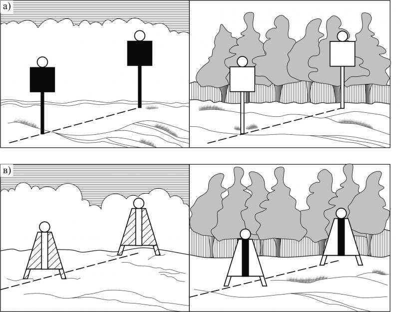
The pass sign serves as a guide for choosing a course on winding rivers with a fairly wide channel (when more precise indication of its direction using cross-sections is not required). These are two clearly visible square shields, attached to the upper end of the pillar so that their planes are located strictly perpendicular to the recommended axis of the ship's passage, which in this place passes (“crosses over”) from one bank to the other. When you see such a sign on the shore ahead, point straight at it in such a way that visible form the shield was as close as possible to a square. Having caught up with the sign, gradually move the boat (“cross over”) to new course, the correctness of which can be judged by the shape of the second shield of the same sign remaining behind the stern. Of course, in this case it is also necessary to monitor the floating situation along the course, which can protect individual dangers protruding into the ship's passage.
In cases where it is necessary to ensure a greater visibility range, type II pass signs are installed. They differ in that inclined trapezoidal lattice panels are added in the lower part, deployed in the same way as the upper square ones.
Pass signs are painted white or red, depending on the background against which they are visible from the river.
In general, most signs are colored depending on the bank on which they are installed - the right bank (looking downstream) is assigned a red color on the river, the left - white. Accordingly, the signs are illuminated at night: on the right bank - with a red light, on the left - with white or green (if there are many other white lights).
Don’t be surprised if the pass sign post is painted with alternating stripes of white and red (or black) colors - this is sometimes done for better visibility.
running sign
The navigation sign - a diamond-shaped shield on a pole - shows that the shipping route goes in the immediate vicinity of this shore and along it. The width of the non-navigable coastal strip, stipulated by local navigation rules, usually ranges from 10 to 30 m from the shore. Within this strip, even a vessel with a shallow draft is not guaranteed against encountering any underwater obstacle - a sunken barge, piles, trees that have fallen into the river.At night, traffic signs are clearly visible - they are easy to distinguish thanks to flashing lights.
The shields of running signs are always made three-dimensional, that is, no matter what angle you look at them from, a diamond shape is always visible.
You can safely follow along the coast, on which there are navigation signs, only within the boundaries indicated by the pass signs: if you come to this, correct your course.
Landmark signs
“Landmark” signs (spring signs) are placed on rivers that overflow their banks in the spring so that the navigator can judge the position of the edge of the bank, flooded with water. Like running signs, they have three-dimensional upper figures (on the right bank there is a ball, on the left bank there is a cone). The lights on these signs are group flashing - with two flashes.Leading signs
Leading marks are installed where it is necessary to indicate a straight navigation course more accurately than this can be achieved with the help of cross-over and navigation marks.Linear signs
Depending on the required detection range of signs, they can have different sizes and configurations. Also shown are the most common linear signs of types I (with square shields) and II (with square shields at the top and trapezoidal at the bottom). If the closed section of the shipping channel is of significant length (10-15 km), it is necessary to make leading signs in the form of tetrahedral truncated pyramids, sometimes up to 15 m high, with the front plane covered with boards.Shields of linear sections are located perpendicular to the direction of the navigation; the rear sign is always higher than the front one. When following the fairway accurately, these boards must be aligned with each other vertically; on sections of types II, III, IV, vertical stripes are combined - black (on white shields) or white (on red). At night, the marker lights may be illuminated with white, green or red lights, but the front sign will always have a steady light and the rear sign will have a flashing light.
It is not difficult to learn to walk along the lines when they are located in front, but it is useful to practice following the ship's course when the signs are positioned behind the stern of the vessel (it must be borne in mind that most often they are installed only at one end of the channel section).
Slotted gates
A variety of alignments are slotted alignments, which, in contrast to linear ones, indicate not only the axis of the shipping channel, but also its lateral boundaries. Such alignments no longer consist of two, but of three alignment marks arranged in a triangle - two in front and one in the back. If you are walking exactly on the axis of the fairway, the back tee is visible halfway between the front tees. If the rear gate and any of the front ones are aligned vertically, then the boat has reached the edge of the shipping channel. And if the boat left the shipping channel, the rear sign will be on the outside of one or another of the front signs.The lights on slotted gate signs are the same as on linear ones: front constant, rear flashing.
Edge leading marks
There is another type of alignment - edge alignment marks, indicating the position of the right or left edge of the fairway. Two signs are placed on the line of each edge: the front one in the form of a rectangular shield and the rear one - with a shield in the shape of a rectangular trapezoid, the inclined edge of which always faces the direction of the shipping lane (only one edge can be indicated with such a sign). The shields are painted according to the edge that they limit: the right signs are red, the left signs are white.If the ship is moving along the shipping lane, then both pairs of marks are in “dissolution” - the rear marks are visible between the front rectangular shields. If any pair of shields closes, it means the boat has reached the very edge of the shipping lane (in the position of the alignments shown on the tab, it is better not to go to the right!) Let us explain that edge marks are considered in alignment when the corresponding vertical inner edge of the front mark and the outer one are combined rear
At night, red lights are on on the leading edges of the right edge, and green on the left edge. The front lights are constant; the rear ones give two flashes with a long interval between each pair.
Lights on bridges. Masts
Lights on bridges. Masts. When approaching the bridge, it is easy to find the navigable span using the red shield attached to the truss (on the upper side of the bridge, i.e., for passage along the current, it has the shape of a rhombus; on the lower side, it is square). However, the boat driver is advised to reduce speed, since it is possible that the passage is open to oncoming vessels.Note the bank near the bridge; Is there a semaphore mast or a traffic light here that regulates the passage of ships from above and below? The markings on the mast are similar to those shown on the inset.
At night, the bridge span that is open to traffic is indicated by two red lights located vertically. Two green lights indicate a span that only tugboats with rafts are allowed to enter.
There are still many floating and pontoon bridges on some rivers. During the day, the boatmaster can easily find the passage when it is open. At night, the floating bridge is illuminated by a number of permanent white lights installed on it at least every 50 m. The open passage is indicated by two lights located one above the other: red at the right end of the passage, green at the left. The third fire burns at the end of the adjustable part set aside.
Yacht captains, when approaching a bridge, usually begin to worry whether the mast will pass under the trusses. You can navigate by the green lights attached to both bridge abutments that limit the navigable span. If two lights are on, the height of the bridge span is less than 10 m, three - 10-15 m; with four lights the span height is more than 15 m.
Crossing signs
Let us remind you that yachtsmen should also pay attention to the signs of air crossings, which are placed at a distance of 100 m above and below power lines crossing the river. On small rivers and canals these signs and lights may be attached directly to the air crossing masts.Attention sign
Such signs mark off an area in which the boatmaster must exercise special caution. These can be sections of the river within the city, near the beaches, at the confluence of side tributaries, where intensive traffic of vessels is possible in a direction transverse to the main course. At night, this sign is recognized by its yellow flashing light.A number of minor signs that are informational in nature and understandable from the inscriptions on their shields (“Signal”, area, mileage indicators, etc.) are not shown on our tab.
It is useful for an amateur navigator to remember about traffic lights and restrictive lights at the entrance to the lock. The traffic light has red and green lights; Restrictive lights, indicating the line beyond which ships should not approach the gate while waiting for locking, are made in the form of red gas-light tubes installed on both embankments of the canal.
Coastal navigational marks depending on their purpose, they are divided into two groups: designations of the position of the navigation channel and information .
To shore signs indicating the position of the navigation channel These include gate, pass, way, spring, “Landmark” signs, bridge span signs and “Tracking light”.
Coastal markers consist of a support pillar and a shield of a certain shape and color mounted on it. For these signs, signal boards of five types are used: rectangular, square, trapezoidal, round and combined. The shape of the shield depends on the purpose of the coastal mark.
The dimensions of signal boards, depending on the range of the sign, are regulated by the State Standard. The height of shore signs is determined by a special calculation taking into account the relief of the shoreline.
On inland waterways, axial (linear), slot and edge gates are used.
Axial alignment(Fig. 6.1) consists of two signs - front and rear, identical in shape, located along the axis of the navigation channel.
Rice. 6.1. Layout of axial sections on the river section:
1 – axis of the navigation channel; 2 – sections on a light background; 3 – sections on a dark background
On axial alignment signs, four types of signal boards are used: square (Fig. 6.2, a), rectangular (Fig. 6.2, b), trapezoidal (Fig. 6.2, c) and combined (Fig. 6.2, d - the top board is square, located vertically, and the lower one is trapezoidal, located obliquely to the vertical).

Rice. 6.2. Axial alignments for light (left) and dark (right) terrain backgrounds
(the part of the sign area painted red is conventionally indicated by shading)
The color of signal boards is chosen depending on the background of the surrounding area. If the background is light, the shields are painted red with a white or black vertical stripe in the middle, and if the background is dark - white with a black vertical stripe, and if they are located against the sky - then black.
At night, there is a red, white or yellow signal light on the axial direction signs of the right bank, and green, white or yellow on the left bank signs. In this case, the character (mode) of the light of the front sign is constant, and that of the rear sign is flashing or constant.
IN
Rice. 6.3. Orientation along the axial alignment: a – the vessel is in the target zone; b – the vessel left the target zone; 1 – axis of the navigation channel; 2 – rear target sign; 3 – front target sign; 4 – shore; 5 – isobath of guaranteed depth; 6 – sighting curves limiting the target zone; 7 – alignment axis; 8 – imaginary vertical passing through the target lights; 9 – rear sign light; 10 – front sign light
Axial alignment serves to indicate the axis of the ship's passage. The principle of its operation is as follows (Fig. 6.3). Two guidance signs or lights - front and rear, located on the shore at some distance from each other, form a guidance line, the extension of which towards the water space must coincide with the position of the axis of the navigation channel. A sign that a vessel is on the leading line will be the location of the front and rear marks or lights on the same vertical (Fig. 6.3, a). Deviation of the relative position of the front and rear signs or lights from the vertical indicates that the vessel is deviating away from the axis of the navigation channel and leaving the channel area (Fig. 6.3, b). When the vessel leaves the guidance zone, the navigator must change course to return to this zone.
Slotted gate consists of three signs - two forward and one rear and serves to indicate the position of the navigation channel and its edges (Fig. 6.4).
The two front signs are installed on a line perpendicular to the axis of the target and are located at the same distance from it. The rear sign is installed on the axis of the alignment, which must coincide with the axis of the navigation channel.
Signal boards for slotted gate signs are of one type - rectangular in shape. They are painted depending on the background of the surrounding area: on a light background - red with a white or black vertical stripe in the middle (Fig. 6.4, a), on a dark background - white with a black vertical stripe (Fig. 6.4, b).
White or yellow signal lights are used on slotted signs, constant lights are used on front signs, and flashing lights are used on rear signs. If there are extraneous lights in the area where the slotted section is located, red signal lights are used on signs installed on the right bank; green lights are used on the left bank. In this case, the front lights are constant, and the rear lights are flashing.

Rice. 6.4. Layout of the slotted section on the section of the waterway: 1 – axis of the navigation channel; 2 – alignment axis; 3 – alignment signs; a – slotted door for a light background; b – slotted gate for a dark background
The principle of operation of the slot gate is shown in Fig. 6.5. When the vessel moves along the axis of the navigation channel (Fig. 6.5, a), the rear sign (light) is visible exactly in the middle of the distance between the front signs (lights). As the vessel deviates from the axis of the navigation channel, the symmetry of the location of the signs is broken (Fig. 6.5, b), while the clearance between the rear and front signs of the edge to which the ship is approaching is reduced.If the ship goes beyond the boundary of the target zone (Fig. 6.5, c), the gap between the shields of the rear and one of the front signs disappears.
The navigator must not allow the vessel to leave the specified zone, since this does not ensure traffic safety.
Slotted sections are used mainly in reservoirs and estuaries of large rivers.

Rice. 6.5. Orientation along the slot opening:
a – vessel on the alignment axis; b – the vessel deviated from the alignment axis; in - the ship leftfrom the target area; 1 – axis of the navigation channel; 2 – isobath of guaranteed depth; 3 – alignment axis; 4 – rear sign; 5 – front sign; 6 – sighting curves, forming the target zone
Edge flap intended to indicate one edge of the navigation channel. The target consists of two characters - the front one and the higher back one. The alignment axis intersects the vertical edge of the rear sign facing the fenced edge of the navigation channel. The front sign is slightly shifted from this axis towards the same edge. To indicate both edges of the navigation channel, two edge alignments are installed - left and right (Fig. 6.6).The signal board of the front edge sign has a rectangular shape, and the rear one has the shape of a rectangular trapezoid. Signs are painted white on a dark background, and red on a light background. Lights - green on the left edge, front constant, rear double-flashing; on the right edge there are red ones, the front is constant, the rear is double-flashing.
P
Rice. 6.6. Edge section: 1 – flow direction; 2 – left edge of the navigation channel; 3 – right edgeship's progress; 4 – leading signs to indicate two edges of the navigation channel

Rice. 6.7. Types of signal boards for pass signs:
a – square; b – rectangular; c – combined
Passage signs(Fig. 6.7) are coastal navigation signs to indicate the direction of a ship's passage moving (transferring) from one shore to another, as well as to indicate the beginning and end of a section with a deep (navigable) shore.A pass sign consists of a support pillar and a signal board of a certain shape mounted on it. There are three types of shields for pass signs: square (Fig. 6.7, a), rectangular (Fig. 6.7, b) and combined (Fig. 6.7, c). Signs located on a light background of the area are painted red, and on a dark background – white.

Rice. 6.8. Running signs
Running signs(Fig. 6.8) are shore signs that indicate that the shipping channel is located along the deep shore on which they are installed. They consist of a pillar - a support and a signal board - a rhombus (Fig. 6.8, a), or a shield in the form of an elongated rhombus with sharp corners cut off (Fig. 6.8, b). To ensure visibility from all directions, shields are usually made three-dimensional. This is achieved through a cross-shaped connection of two flat shields (diamonds) or by connecting two shields (elongated rhombuses) in plan at an angle of 90.The color of the shield and the pillar of the navigation sign, in contrast to the leading and pass signs, depends on the name of the bank on which it is installed. On the right bank the color is red, on the left bank it is white. To create a contrast with the background of the area, the supports of the running signs are painted with alternating stripes of red and white on the right bank and white and black on the left bank.

Rice. 6.9. Spring signs
The traffic signs on the right bank have red flashing lights, and the signs on the left bank have green flashing lights.Spring signs(Fig. 6.9) are installed to indicate banks flooded during high water, islands, capes protruding into the riverbed, etc. They do not directly indicate the axis or edge of the channel and serve to determine the position of the channel together with other signs.
The spring sign is a signal figure mounted on a support pillar, consisting of two cross-shaped shields, shaped like a circle on the right bank (Fig. 6.9, a) and a trapezoid on the left bank (Fig. 6.9, b). The signal figure can also be made of three planes intersecting at an angle of 120 in plan.
The shields of spring signs on the right bank are painted red, and on the left – white. The sign supports are painted the same color as the shields.
At night, the signs on the right bank have permanent red lights, and the signs on the left bank have permanent green lights.
Sign« Landmark"(Fig. 6.10) are used on rivers and reservoirs to designate characteristic banks, capes, islands and other noticeable places on the coastline. They do not directly indicate the position of the navigation channel, but allow navigators to determine it indirectly (by the position of the vessel relative to the Landmark sign).
By design, signs are made in the form of pillars with two shields (Fig. 6.10, a) and three or tetrahedral prisms and pyramids (Fig. 6.10, b). Two types of signal boards are used: rectangular and trapezoidal.

Rice. 6.10. Landmark signs:
a – in the form of single pillars with signal boards;
b – in the form of three and tetrahedral prisms and pyramids
Signboards installed on the right bank are painted with five alternating horizontal stripes of red and white, and on the left bank - black and white, with the top stripe being red or black, respectively.
The "Landmark" signs on the right bank have red, white or yellow double-flash lights, and the signs on the left bank have green, white or yellow double-flash lights.
"Lighting Light" Signs(Fig. 6.11, a) serve to mark the banks of the shipping canal at night. The shape of signs carrying directional lights is not regulated. Structurally, the sign is a support, at the top of which there is a lantern with two lenses in the side walls. An electric lamp is placed in the lantern. Through the lenses of the side walls, signal lights shine along the bank of the canal. On the right bank there are red constant or flashing lights, on the left bank there are green constant or flashing lights.
Identification marks(Fig. 6.11, b) serve to mark the entrance to a canal, port, outport, shelter from the side of a lake or reservoir.

Rice. 6.11. Sign "Tracking light" (a) and identification marks (b)
Signs are constructed in the form of towers of various architectures and installed on the heads of dams, piers and breakwaters. They are painted in a color that provides the necessary contrast with the surrounding background of the area.At the tops of the identification signs, permanent or flashing all-round signal lights are installed: green on the left bank signs and red on the right bank signs.
On the sides of the markings facing the shipping channel, a permanent light of the same color as on their tops may be installed.

Each lighthouse has its own distinctive shape, color and fire characteristics. Descriptions of lighthouses and their geographical coordinates are given in the corresponding directions and on maps.

Rice. 6.13. Navigation sign
Luminous marine navigation sign(luminous sign) - a means of navigation equipment for the seas and large lakes, which is a day and night landmark of a special construction, having a light-optical device with a white light visibility range of up to 10 miles. This is a structure of the same type as the lighthouse, but of lighter construction (Fig. 6.13). The shape of navigational signs can be different; they are constructed from stone, brick, metal, wood, etc. The sign may have distinctive shields and top figures. Radar reflectors are often installed on them.Non-illuminated navigation sign- a structure of the same type as a luminous sign, but without a light-optical apparatus.
Marine navigation light (light)- a means of navigation equipment for seas and large lakes, which is a night landmark and is a light-optical device installed on natural objects or non-special constructions (building, rock, pillar, etc.).